
Galveston Bay
Below are resources for teaching about the bay in your learning environment.
Overview | Benefits | Conservation | Wildlife | Cultural Connections
Overview

Galveston Bay Watershed Courtesy of Galveston Nature Tourism. Find your watershed with this tool.
Galveston Bay is the state’s largest bay. The San Jacinto and Trinity Rivers (in addition to bayous and creeks) drain fresh water, sediments and nutrients into this semi-enclosed system, which mixes with salt water from the Gulf of Mexico. Estuaries are among the most productive ecosystems in the world, and 95% of fish species in the gulf are dependent upon the bay.
Abiotic factors include water and air temperature, pH (acidic or basic), dissolved oxygen, salinity (affected by freshwater inflows), nitrogen and phosphorus levels, and turbidity/transparency. A biotic factor is fecal indicator bacteria, in addition to wildlife population surveys.
There are many types of ecosystems in Galveston Bay. Healthy ecosystems provide food, clean water, shelter and nurseries to wildlife.
An estuary is a place where rivers, like the Trinity and San Jacinto, meet the ocean. There is a mixing of fresh and salt water.

Brown Pelican numbers are rebounding. The long beak acts like a net, enabling it to catch fish. Photo courtesy of Houston Audubon and Greg Lavaty
A salt marsh lines the landward side, touches the salty water of the bay, and is home to cordgrasses like Spartina alterniflora that slow the flow of water, allowing sediments and pollutants to settle out. It’s a muddy, mucky place with changing salinity, temperature and water levels. Birds here have wide feet for walking through the mud. To learn about their benefits, check out the Texas Coastal Exchange.
A brackish, or intermediate, marsh is characterized by plants that tolerate both salt and fresh water conditions due to occasional strong storm surges that flood inland areas with salt water.
A bay is a body of water, partially enclosed by land and directly connected to the ocean. Underwater seagrass beds stretch to the gulf, and oyster reefs grow in deeper water with a current.
Benefits
According to the Galveston Bay Estuary Program, the bay:
Supplies millions of tons of shrimp and oysters each year, to the delight of migratory birds, people and spawning fish!
Is an essential stopping point for millions of migratory birds.
Is the boating capital of Texas - used by an estimated 90,000 boaters each year!
Is a giant filter of the freshwater that pours in from surrounding rivers and bayous.
Conservation
Organizations like the Galveston Bay Foundation and programs like the Conservation Assistance Program of the Galveston Bay Estuary Program are focused on five key issues facing the bay:
loss & degradation of habitat
need for lands under conservation
insufficient fresh water inflows from rivers, bayous and creeks
poor water and sediment quality
lack of public awareness
Wildlife
Estuaries are like a nursery for young finfish and shellfish. As freshwater flows in from rivers and bayous, the nutrients feed seagrass and plankton. These autotrophs, or producers, turn sunlight into energy through photosynthesis and form the base of the food web.
Oysters filter water in order to eat plankton, and oyster reefs provide habitat for small fish. Oysters also filter out detritus and sediment, helping to clean the bays. Red drum and spotted seatrout, two popular finfish, are predators in the system. They spawn in the bay but often return to the open ocean when bay temperatures are too cold. Other predators include birds like brown pelicans and herons.

Aquatic Food Web. A web is a model that shows the interconnectedness of a system; a chain, however, only shows one piece of the puzzle. Photo courtesy of Texas Aquatic Science

A Yellow-Crowned Night Heron, the official Bird of Houston, has wide feet and long legs. These adaptations allow it to walk and hunt with its sharp beak in the marshes. Photo courtesy of Wild South Florida.
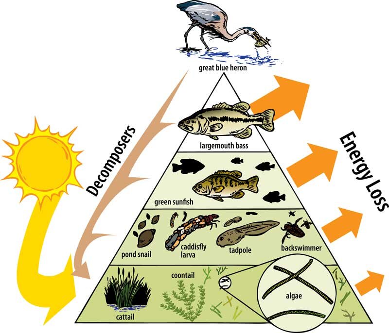
Aquatic Food Pyramid. Due to the Second Law of Thermodynamics, up to 10% of the energy at each trophic level is lost as heat. Courtesy of Texas Aquatic Science
To check on the health of this interconnected system, scientists monitor many different populations.
One is shellfish (blue crabs, oysters and shrimp). Currently, populations are stressed by decreasing habitat. To help, you can volunteer to remove abandoned crab traps, reduce your consumption of shellfish and conserve water to protect freshwater inflows.
A second monitored population is finfish, like Atlantic croaker, bay anchovy, drum, seatrout and catfish. Finfish numbers have remained stable since 2004; to protect them, reduce runoff pollution and support the protection of habitat.
A third monitored population is birds, and most of the species numbers have remained the same. Especially hopeful are the rebounding numbers of Brown pelicans. You can learn more about coastal bird species from Houston Audubon. To help, you can pick up trash in the habitat.
Invasive species can ruin an ecosystem because they disrupt feeding patterns and outcompete native species. Once established, especially in aquatic environments, they are very difficult to remove. Search for invasive species in the bay with this tool from HARC. It’s important for recreational boaters to clean, drain and dry their boat, trailer and gear in order to remove invasive hitchhikers. Pet owners should never release plants or animals into the environment.
Cultural Connections
Galveston Island and Bolivar Peninsula formed from shoreline deposited sediments thousands of years ago, and have been inhabited by people ever since. Akokisa (Orcoquisa) tribes lived here 7,000 years ago, followed by the Karankawa, Coco and Tonkawa tribes. Cabeza de Vaca was stranded on the Texas coast in 1528. Jose Antonio Evia surveyed the entire Gulf coast in the late 1700’s and named the area “Galveston Bay” in honor of his patron, the Spanish Governor of Louisiana, Bernardo de Galvez.
The deciding battle in Texas’ war for independence from Mexico was fought at the confluence of the San Jacinto River and Buffalo Bayou, and later Texas was annexed to the United States. In 1850, Galveston was identified as the largest town in Texas due to its navigational improvements. Industrialization and oil refineries soon followed, as did a widening and deepening of the Houston Ship Channel and a degrading ecosystem. Today, half of the population of Texas lives in the Galveston Bay watershed - and even more people depend upon its extensive resources.
“Native Land Digital creates spaces where non-Indigenous people can be invited and challenged to learn more about the lands they inhabit, the history of those lands, and how to actively be part of a better future going forward together.” Visit this interactive map.
Local Resources
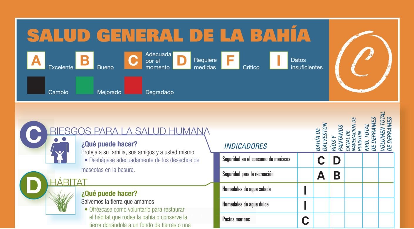
Find your watershed with this tool from the Galveston Bay Foundation. The Galveston Bay Report Card is a citizen-driven, scientific analysis of the health of Galveston Bay. Also available in Spanish. It explores six categories: water quality, pollution events & sources, wildlife, habitat, human health risks, and coastal change. It makes a great primary source for student exploration.

Artist Boat operates five-star guided kayak adventures, Eco-Art workshops, and summer camps in the bay.
The Galveston Bay Estuary Program offers programs and resources to support their mission to preserve Galveston Bay for generations to come.
Galveston Island State Park is a fun place to fish, hike, geocache, survey wildlife with iNaturalist or test water quality. Contact the park to customize your experience.
Bolivar Flats Shorebirds Sanctuary is free to visit. Contact Houston Audubon for more information.
Trinity Bay Discovery Center on the bay is operated by the Galveston Bay Foundation.
At Home with the Bay digital learning program.
Wetlands Connections is a year-long project connecting students to their local Bay as they restore area wetlands by growing and maintaining marsh plants on school grounds, planting them at the end of the year. Includes two field trips, campus wetland supplies, support staff, and two classroom workshops.
Anahuac National Wildlife Refuge is on the bay, and is operated by the U.S. Fish and Wildlife Service.
Armand Bayou Nature Center features multiple ecosystems as a living laboratory. Immerse your students in this spectacular space.
Take an interdisciplinary field trip to the San Jacinto Monument and Big Energy exhibit at the San Jacinto Museum, then visit the new Galveston Bay Foundation headquarters on the Kemah Boardwalk.
Stopping Plastics and Litter Along Shorelines (SPLASh), a program of the American Bird Conservancy, regularly hosts coastal cleanups, engages local students with educational programs, and drive best waste management practices in communities.
Activities/Lessons
Visit the NOAA Estuary Education website for lesson plans or NOAA Educator Resources to teach ocean literacy from the National Marine Sanctuaries. This includes virtual field trips and live interactions with staff from the NMS program.
Galveston Bay Foundation has free curriculum, TEKS-aligned, K-12.
Elementary School
Students create a social media campaign to increase public awareness about issues facing the bay, using tools from the Galveston Bay Report Card and Stop Aquatic Hitchhikers. One step further, students participate in Bay Day.
Middle/High School
Texas Aquatic Science is an online curriculum & textbook.
Galveston Bay Foundation offers "At Home With The Bay," a series of educational videos featuring a virtual lab, conservation craft, talk with a Bay biologist and an activity (all in Google Drive). Use tools from the Galveston Bay Report Card (also available in Spanish) and Stop Aquatic Hitchhikers, and participate in Bay Day. Check out their extensive curriculum guide, too. Complete with background information, activities & lesson plans.
Engage students by virtually looking for birds in the estuary with the Bolivar Flats Bird Cam (like Brown pelicans). Compare species with those found in the city of Houston with the Edith L. Moore Bird Cam (like cardinals). Then, study adaptations of different birds in each area. Relate adaptations to evolution and natural selection (7th Grade TEKS 10 & 11, Biology TEKS 7 & 8).
Watch the free movie, Microplastics Madness. Review Marine Debris resources from NOAA to learn more about the problem with plastics, and sensible solutions.
Vernier LabQuest has multiple sensors to measure abiotic factors, or LaMotte sells water quality test kits. Sample waters found in your learning environment and compare your data with that of Galveston Bay sites (TEKS 1 - 3).
Use the Smarter About Water program to teach water conservation. Contact Kristi Pierce at the Harris Galveston Subsidence District for help with programming. (7th Grade TEKS 8, 8th Grade TEKS 11)
Rising Tide - “The Ocean Podcast” offers us all a chance to hear from some amazing yet salty people. Check out their short 5-minute pilot podcast.
NOAA Data in the Classroom students use real-time ocean data to explore today’s most pressing environmental issues, and develop problem-solving skills employed by scientists. Access online and classroom-ready curriculum activities with a scaled approach to learning and easy-to-use data exploration tools.
For marine debris curriculum, start with NOAA Talking Trash and Taking Action.
Just an idea… students create a card of information for various species found in the food web for Galveston Bay. Students stand in a circle, each holding one species card. Start with a ball of string in the hands of producers, and students toss the string to predators, thus creating the web. Introduce factors in species decline to model the effect on the web. For example, a lack of nutrients from freshwater inflow directly reduces plankton populations; how does this effect other populations? (8th Grade TEKS 11, Biology TEKS 12).
Dive into the Science of Sand resources! You can mail them sand, and they will give you a report of where it came from (what a neat watershed lesson). Great for Earth & Space, Environmental Science, Chemistry, and CTE courses.
Videos
At Home with the Bay - Digital Resource from Galveston Bay Foundation
Overview of Houston’s ecosystems, with key vocabulary.